Types of transport
Yandex Maps plots routes for different types of transport. To view and compare all the available options, plot a route and tap .
Start plotting a route and select the appropriate transport type:
— By car ( , if you selected a truck).
— By public transport.
— On foot.
— By bicycle.
— By scooter.
The features of each option are described below.
Passenger car or truck
Alert
You can only create truck routes online and within Russia or Türkiye.
In the app, you can plot routes for passenger cars and trucks. Such routes take into account various road restrictions, such as weight limit signs or speed limits.
To select a truck:
To switch between a passenger car and truck, tap and select the variant you need. If you're already moving along a route, reset it, plot the route again, and select a passenger car or truck.
Set the route parameters:
Exclude toll roads
- Tap and enable the Avoid toll roads option.
Exclude poor quality roads
- Tap and enable the Avoid bad and unpaved roads option.
Select the departure time and date
-
1. Tap at the bottom of the screen.
2. Select the date and time.
3. Tap Done.The route will be updated taking into account the specified parameters. To reset the route for the current time, tap Reset at the bottom of the screen.
To start moving along the route, tap Go. The travel time will be recalculated.
By public transport
You can check the list of cities and countries where you can plot routes by public transport, as well as set the type of transport, departure and arrival times.
When you select a route, the time when the transport arrives at the stop is specified. This information can be shown in one of the following ways:
-
Exact arrival time: "Arrives at 11:28".
-
Arrival time based on the interval: "Interval 2 min".
-
Arrival time based on the schedule: "Scheduled at 12:23".
-
If the the route is not in service today or the transport will start running tomorrow only: "Not in service today", "In service from 05:20".
If there is no transport data, the arrival time isn't displayed.
How the arrival time of public transport looks like
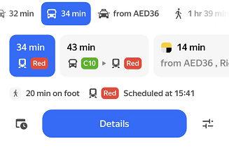
The numbers in the colored squares indicate the numbers and types of transport. Tap Details to see route details.
Set the route parameters:
Select transport types
-
1\. Tap <svg width="24" height="24" viewBox="0 0 24 24" fill="none" xmlns="http://www.w3.org/2000/svg"><path fill-rule="evenodd" clip-rule="evenodd" d="M14 7V5C14 4.44772 14.4477 4 15 4C15.5523 4 16 4.44772 16 5V11C16 11.5523 15.5523 12 15 12C14.4477 12 14 11.5523 14 11V9H4C3.44772 9 3 8.55228 3 8C3 7.44772 3.44772 7 4 7H14ZM8 17H4C3.44772 17 3 16.5523 3 16C3 15.4477 3.44772 15 4 15H8V13C8 12.4477 8.44772 12 9 12C9.55228 12 10 12.4477 10 13V19C10 19.5523 9.55228 20 9 20C8.44772 20 8 19.5523 8 19V17ZM18 7H20C20.5523 7 21 7.44772 21 8C21 8.55228 20.5523 9 20 9H18V7ZM12 15H20C20.5523 15 21 15.4477 21 16C21 16.5523 20.5523 17 20 17H12V15Z" fill="black"/></svg> at the bottom of the screen.
2\. Choose the preferred transport types.
3\. Tap **Done**. Yandex Maps will prioritize routes with your selected transport type.
Select the time and date of departure or arrival
-
1\. Tap <svg width="24" height="24" viewBox="0 0 24 24" fill="none" xmlns="http://www.w3.org/2000/svg"><path d="M9.57026 19L5 19C3.89543 19 3 18.1046 3 17V6C3 4.89543 3.89543 4 5 4H17C18.1046 4 19 4.89543 19 6V8.39838C18.2135 8.13985 17.3731 8 16.5 8C16.376 8 16.2528 8.00282 16.1302 8.0084C16.0876 8.00286 16.0441 8 16 8H6C5.44772 8 5 8.44772 5 9V16C5 16.5523 5.44772 17 6 17H8.75204C8.93466 17.7095 9.21218 18.381 9.57026 19Z" fill="#4D4D4D"/><path fill-rule="evenodd" clip-rule="evenodd" d="M16.5 22C13.1863 22 10.5 19.3137 10.5 16C10.5 12.6863 13.1863 10 16.5 10C19.8137 10 22.5 12.6863 22.5 16C22.5 19.3137 19.8137 22 16.5 22ZM16.7055 12.25C16.8018 12.25 16.8824 12.3229 16.8921 12.4186L17.246 15.911L19.5044 17.3944C19.6015 17.4582 19.6341 17.5854 19.5795 17.6881L19.3649 18.0916C19.3114 18.1923 19.191 18.237 19.0848 18.1957L16.2354 17.0886C15.9166 16.9648 15.7305 16.6469 15.7513 16.3226L16.1094 12.4204C16.1182 12.3239 16.1992 12.25 16.2961 12.25H16.7055Z" fill="#4D4D4D"/></svg> at the bottom of the screen.
2\. Select **Departure** or **Arrival**.
3\. Select the date and time.
4\. Tap **Done**.
The route will be updated taking into account the specified parameters. To reset the route for the current time, tap Reset at the bottom of the screen.
If you moved 100 or more meters away from your original location when plotting a public transport route, you can update the route. To do this, tap : the route will be rebuilt from your current location.
On foot
Note
If you've planned a walking route, you can easily switch to ordering a taxi instead. You can also order a taxi while you're still deciding on your mode of transport ( icon). To do this, just tap  .
.
The route may display terrain info which includes the number of steps and changes in height. Steep climbs are highlighted in red.
Terrain info for a walking route
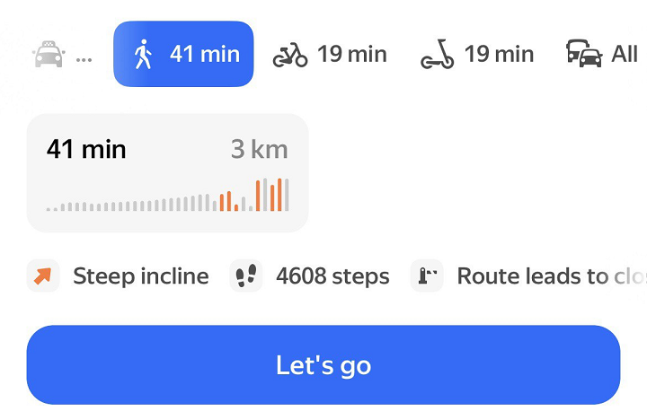
Terrain info is shown for some cities of Armenia, Belarus, Kazakhstan, Russia, Serbia, and Türkiye.
If there's insufficient data about elevation changes, you won't see the terrain info.
The app also shows the number of stairs on the route.
When plotting walking routes, you can select the easiest one:
-
Tap at the bottom of the screen.
-
Enable these options:
-
Suggest easier routes: The app will first show the easiest route: the one with the fewest stairs and inclines (both regular and steep).
-
Avoid stairs: The app with first show the route without stairs. If a stair-free route isn't available, the app will show a route that minimizes stairs and prioritizes ramps. The route description shows how many stairs have ramps.
-
-
Tap Done. The route will be updated taking into account the specified parameters.
If both options are enabled, the app will first show a route that meets at least one condition.
By bike or scooter
Route sections are highlighted in different colors:
- Green indicates a bike path or a sidewalk.
- Purple indicates roads with traffic.
- Gray indicates a closed area.
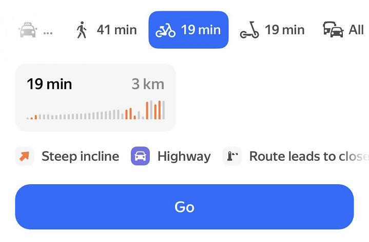
The route may display terrain info which includes the number of changes in height. Steep climbs are highlighted in red.
Terrain info for a bike route
Terrain info for a scooter route
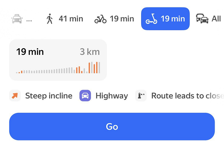
Terrain info is shown for some cities of Armenia, Belarus, Kazakhstan, Russia, Serbia, and Türkiye.
If there's insufficient data about elevation changes, you won't see the terrain info.
The app also shows the number of stairs on the route.
When plotting bike or scooter routes, you can select the easiest one:
-
Tap at the bottom of the screen.
-
Enable these options:
-
Suggest easier routes: The app will first show the easiest route: the one with the fewest stairs and inclines (both regular and steep).
-
Avoid stairs: The app with first show the route without stairs. If a stair-free route isn't available, the app will show a route that minimizes stairs and prioritizes ramps.
-
-
Tap Done. The route will be updated taking into account the specified parameters.
If both options are enabled, the app will first show a route that meets at least one condition.
Scooter etiquette
- You will see the Scooter etiquette: ride safety message when you first plot a scooter route. Tap Learn more and study the tips. After that, the message will disappear.